Occassional thoughts about orienteering
| okansas.blogspot.com Occassional thoughts about orienteering |
|
Friday, October 31, 2003 Junior WOC terrain for 2004Poland will organize the Junior WOC next July. Take a look at the organizer's web page for old maps of the competition terrain.My first reaction when I looked at the maps was that the terrain looked a bit like some St Louis areas. My second reaction was that the terrain reminded me a bit of some of the areas Japan will use for the 2005 WOC. The terrain looks interesting -- the course setters ought to be able to set courses that offer challenging route choices. posted by Michael | 5:07 PM Thursday, October 30, 2003 World Class O' Terrain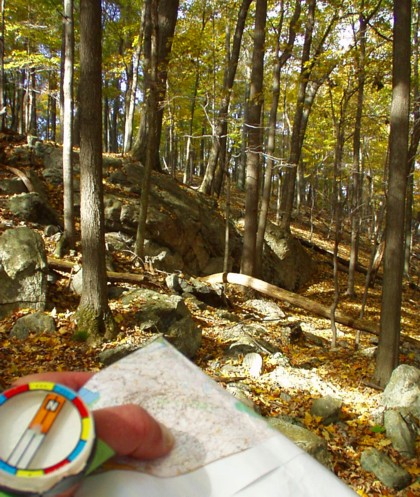
Harriman State Park, New York, October 24, 2003. posted by Michael | 7:41 PM Wednesday, October 29, 2003 A few notes on the WCOC A-meetI haven't had time to carefully go over my performance or scan my maps, but I'll throw out a few thoughts.First, you can take a look at the M35 course on Peter's web page (with Peter Gagarin's routes). The terrain was more "pleasant" than I expected. The map has a lot of light green, but the vegetation is very nice. The light green didn't really slow you down. I'd expected the footing to be rocky. In places it was rocky, but overall it was quite nice. Parts of the Hudson Valley have a lot of low underbrush (blueberry bushes, for example), but this area had almost none of that. The course setters made an effort to keep the climb down. I can probably gain a couple of minutes per hour in terrain like this by working on my downhill running. A few years ago I put a lot of emphasis on running better downhill. I got better. But since my leg injury, I've lost all of the improvement. I spent some time on Saturday night looking at the map and thinking about what sort of legs I'd face on Sunday. When I came to the 8th control on Sunday, I looked at the long leg to 9 and recognized it. Saturday night I'd thought about how I would run this leg. When I arrived at 8, another runner on the same course was standing there, looking at the leg and picking his route. He probably stood still for 20-30 seconds. I didn't stand still at all. I'd already decided my route for this leg. (Take a look at 8-9 with Peter's routes here). I took a route very similar to Peter's. I feel like the map study I did on Saturday evening saved me a little bit of time. On the other hand, Randy Hall had a very different experience with studying the map before the race. Check out Randy's entry for October 27. I ran with an Active Ankle on Sunday after turning my left foot on Saturday. I don't usually tape my ankles or use the Active Ankle, but my foot felt weak on Sunday so I thought it was a reasonable precaution. The map was offset print! posted by Michael | 1:16 PM Tuesday, October 28, 2003 DopingI was going to write a bit about last weekend's race when I found an article about orienteering and doping. The Swedish O' Federation published a translation of a press release from the Finnish O' Federation. Here is a translation of a bit of the Swedish text:The Finnish O' Federation has decided to give a warning to the orienteer Anni Kulmala after a doping test in July in France. Here A-sample contained too much psuedoephedrine....Anni Kulmala hasn't asked for the B-sample to be tested and has admitted that she took Duact, a drug for her allergies, which she used and which includes psuedoephedrine. Psuedoephedrine will be removed from the doping list beginning January 1, 2004. "I told the testers I'd been using Duact, which was prescribed by a doctor for my allergies, and I didn't know it was a prohibited medicine," says Anni Kulmala. "I was under the impression that it was ok to use this medicine because it was prescribed by a physician. Now I understand I was wrong. Because I'm considered a recreational orienteer, I haven't studied the doping list," said Kulmala, who in the latest rankings was 94th in Finland. posted by Michael | 6:10 PM Thursday, October 23, 2003 Next planned update on October 28In a few minutes I'm leaving for a trip to visit family and run the Connecticut A-meet. I'm not sure about internet access, so I don't plan to update this page until I get back home.If you need something to read about orienteering, let me offer a couple of suggestions: Mapsurfer.com for lots of interesting maps and comments. Take a look at map collections from a couple of Norwegian orienteers, Karriane Ruud and Lars Skjeset . Finally, here is an experiment... Find the best couple of non-offset printed maps you've got in your collection (in my stack of maps I picked the most recent US Champs and the GLOF) and compare them to the best couple of offset printed maps you've got (I used the WOC maps from 2001 and 1993). What do you see? posted by Michael | 8:51 AM Wednesday, October 22, 2003 ...he doesn't look very fast at all...Mattias raced against Thierry Georgieou (France's world champion) last week and wrote:Thierry went past me at some point during the race, and he doesn't look very fast at all, plus he made a couple of small mistakes!! It's fascinating that he beats the shit out of everyone..or maybe he can even run a lot faster than he did, but he doesn't need to?? When I read Mattias' comment, I thought about how some runners look fast and some don't, but it isn't easy to tell how fast someone is actually going. Some people seem to look relatively slow but make up for it by keeping a very steady pace (Mikell Platt is an example that comes to mind). Others seem to dash through the forest (I remember having Eric Bone fly past me, I couldn't have kept up with him for 100 meters). Some runners seem to be moving slowly, but are actually going faster than they look (if you've ever run a road race with Gene, you know what I mean). *Georgieou ran the about 6:20 min/km for a 5.8 km course in terrain that Mattias described as "absolutely disgusting forest behind, green, rocky, steep, just horrible." posted by Michael | 1:13 PM Tuesday, October 21, 2003 Interview with KarolinaA Swedish newspaper published an article about Karolina Arewang-Hojsgaard, naming her the region's top summer athlete. I've translated a few bits of the original article:I've been healthy and free of injuries, and able to train all year. Plus I've got enormous support from my club, my husband Thomas and friends and relatives. Everyone has supported my efforts and it has gone better than I dreamed. I don't know why I've become so good. But I began well. That gave me good self confidence. I think it means a lot that you believe you can run fast and find the controls. I've also had opportunities -- the new national team coach, Marita Skogum, made sure of that. [Compared to the prior national team coach, Anders Tistad] I have more confidence in Marita. She'd been a top orienteer and knows how we think and feel. Thomas is my trainer now, but I talk about mental aspects with Marita and she's been very supportive. Karolina makes a couple of references to 2001, when she was left off the WOC team despite some good results. At the time I remember reading some very pointed comments she had about Anders Tistad, the national team coach. Judging by the current interview, she's still upset. It sounds like she is either motivated by showing that she should have been selected in 2001, or maybe she's just really angry at Anders and won't miss a chance to tweak him. posted by Michael | 12:55 PM Monday, October 20, 2003 Offset printingIn the 20+ years I've been orienteering in the U.S., I think the sport has moved in the right direction in most aspects. The movement has been slow. There have been starts and stops. But, in general, things are better now than they were when I started orienteering. But, there is a glaring exception.Printing of O' maps is worse than it used to be. Back in the 1980s and 90s, A-meets used offset printing. At local meets, you'd usually get an offset print color map or a black and white map printed on a photocopier. These days the norm is to run on maps printed on some sort of computer printer. That is a step back. Here is a note from the BAOC yahoo group (BAOC hosted the U.S. Champs a month or so ago): Bob reported that although he expected to hear some complaints about the 1:15,000 inkjet (not offset) printing for the US Champs, he did not receive too many.* I have to admit, I didn't complain to the organizers. Why complain? It seems obvious that inkjet printed maps are worse. Maybe we've reached a point where people expect that maps to be printed on inkjet printers. We expect the maps to be hard to read. Offset printing is much easier to read. As I've been doing map study in the last few weeks, I've really noticed how much easier the old offset print maps are to read. Printing maps on inkjet printers has some advantages, especially for small events on areas that are likely to change quickly. Using an inkjet printer to print maps of Clinton State Park for a local meet is fine, because we'll only get 30-50 runners and the mountain bikers are continuously changing the trail network. It is a shame that the quality of an event suffers because the maps are printed on an inkjet. I don't know how much (if any) money a club saves by avoiding offset printing. I can't imagine it is much. But, even if it is $5 a day, it seems like we should be paying the extra money for high quality rather than saving a few bucks and accepting low quality. Maybe it is just me? It isn't just me. Bjornar Valstad criticized the Swedish organizers of the next WOC for having inkjet printed maps at the recent training camp. He wrote, "Half-speed on good maps -- WOC 2004." "Half speed" because the maps were so hard to read that even though they were good, you had to slow down to read them.** Enough ranting...my lunch hour is almost over. Back to work. * For what it is worth, the U.S. Champs maps were fairly well printed given that they weren't offset printed. ** Bjornar's motto is a reference to the Norwegian motto before the 1989 WOC -- "Full speed on bad maps -- beat Sweden at the 1989 World Champs." Back in the late 1980s, Sweden had a reputation for having a lot of bad maps. posted by Michael | 12:59 PM Sunday, October 19, 2003 Nothing to writeI can't think of what to write. So, here are five unrelated thoughts:More inspiration for an orienteer getting old...Hakan Eriksson (42) was named to the Swedish national team. You might remember he won the Swedish sprint selection race but was left of the WOC team. Next year Sweden will have three runners in the sprint race, so Eriksson probably has a better chance of making the team. Blodslitet is a Norwegian race a bit like the Hudson Highlander. This year's race was 24 km. Check out the M21 course here. I think staying healthy and injury free is an important part of training. I've been sick with a cold for a week. I get mad at myself when I'm sick. Although it isn't an orienteering page, Fasterskier.com has some interesting training information. Another thought about next week's race in Connecticut...The footing will probably be rocky. Going from Kansas City to northeast rocky terrain requires an adjustment. I've found that after running in rocky forest for about 20-40 minutes I begin to run smoother. I'll make sure to put in a bit of a run on Friday (the day before the first race) at Harriman. A special 6th bonus unrelated thought! The Hyde Park Campus of the Culinary Institute of America looks like it'd be a good place for some sprint orienteering. Check out the campus map, the USGS topo and an aerial photo. posted by Michael | 8:22 PM Saturday, October 18, 2003 Time to start thinking about next weekendNext weekend I'm going to the A-meet in Connecticut. It is time to start thinking about the race.I've never run in Connecticut before, but I took a look at the map. My first reactions: 1. Those are big hills. Going up or down them will be tough. 2. Finding a control along the side of a hill could be tricky (especially if it requires you to drop a few lines and find a control tucked on the back side of a boulder or low cliff). 3. It looks like the main technique will be to keep fairly good contact and have a good sense of what is in and around the control circle. 4. I don't expect to see complex route choice problems, but there may be some legs that offer the chance to take a route that saves climb. 5. How will the visibility be? Relatively good visibility (as at West Point) would make the orienteering a lot easier. posted by Michael | 8:58 PM Friday, October 17, 2003 Smallest A-meet area ever?One of the cool things about the third day of the GLOF was how much orienteering the course setter (Mike Waddington?) managed to squeeze in to a small area.The entire competition area was about 1,200 meters by 800 meters (just under one square kilometer). The top women ran the course in about 50 minutes and the top men in 55-60 minutes. I think that is about normal for an F21 A-meet and a bit short for an M21 A-meet. The courses were forked. M21 ran three loops while F21 (and M35) ran two loops. The race was a mass start and the courses were forked using the "Farsta" method. Check out the complete course here. Has an A-meet ever been held in a smaller area? posted by Michael | 6:52 PM Thursday, October 16, 2003 The second day in CanadaI had a strange race on the second day of the GLOF in Canada. I was close, very close, to having a good race. Instead, I missed a control, stressed and tried to make up time, missed another control and finally got my act back together. By then it was too late to have a good race.The second day course was short (4.2 km) with a lot of controls (17). Here is a bit of the course: 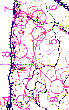
I lost time at 5 and 7. On the way to 5 I caught sight of another runner. When I spotted him, I thought, "I should be able to catch him by the control." What I should have thought (what I probably would have thought on a good day) was, "ok, so there is a guy ahead of me, pay attention to what you are doing...." When I came over the saddle I dropped into the wide depression and looked around. I spotted a depression and ran over to check it out. It was distinct and deep. But, there wasn't a control in it. I looked at the map and realized where I was. So I headed off in the direction of the control, looking for either the depression, control or the boulder. I must have run right by it without seeing it. I saw a trail ahead of me, stopped, saw where I was and turned around and ran back to the control. I ran hard to 6. I was mad about losing time at 5. I shouldn't have been. Once you've lost time it doesn't usually make sense to try to make it up. In fact, I should have taken a few seconds and taken it a bit easier on the 6th control. It worked out ok, I hit 6 without any trouble. But, then I headed off toward 7, still trying to make up time. I missed the control by just a bit, then had to stop to figure out what was going on. The map was a bit hard to read (the map wasn't offset printed) and I spent a few seconds figuring out what was going on before I realized where I had to go. When I found 7 I realized what I was doing. Trying to make up time wasn't going to work. What I needed was to slow down and get my mind back on what I was doing -- read the map and let the terrain and navigation set the pace. The rest of the race went well. I ran well from the start to 4, then from 7 to the finish. But, I'd lost enough between 4 and 7 to lose the race. In retrospect, I probably should have spent some more time before the race thinking through what I was going to do. Even after 20+ years of orienteering, I don't seem to be able to race well without spending a few minutes before the race thinking about what I'm going to do. posted by Michael | 7:05 PM Wednesday, October 15, 2003 SpectatingMary and I had a chance to watch some cycling and orienteering last weekend. We saw parts of a couple of races at the Road World Cycling Champs in Hamilton and the Axis Gear Sprint orienteering.Cycling I think the most impressive part of watching a bike race is seeing the entire pack come flying by. It reminds me of a stock car race (with a lot less noise). Here is a snap shot of the elite men's pack climbing past us on about the fifth of 21 laps. 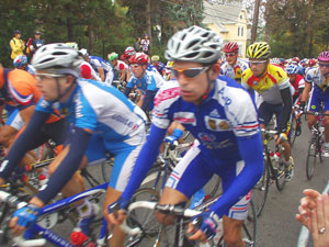
When the pack goes by the impression you get is of a colorful huge thing. There is a lot of motion, but you don't really get a sense of how hard the riders work. When a single rider goes by, you notice how hard they work. Here is a snapshot of Victor Hugo Pena chasing a lone rider who was about 50 seconds ahead. 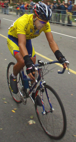
Sprint Orienteering On the evening of the first day of the GLOF, the organizers put on an invitational sprint race. About 6 or 7 runners representing the US, Canada or Ontario raced. Runners started every 30 seconds and the course was only about 2 km. So the entire event took about half an hour. Immediately after the finish, there was a bar-b-q dinner. I watched the sprint while Mary, sick with a cold, rested at the hotel. I hoped to get some nice snapshots of orienteers. The best couple of pictures show Ted De St Croix racing to the finish. 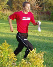
For someone getting old (I'm 39), Ted is inspiring. He's 45 years old and still among the best orienteers in North America. At GLOF he finished 2nd, 3rd and 4th on the individual days. 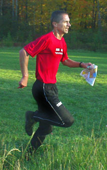 posted by Michael |
5:41 PM
posted by Michael |
5:41 PMTuesday, October 14, 2003 A few words about CanadaI'll probably write a bit about our O' trip to Canada over the next few days. I should have plenty of time. I picked up a wicked cold and I'm going to be spending a day or two at home where I have plenty of time to write. Unfortunately, having a wicked cold means I'm not really motivated to write.The short report -- good courses, maps and terrain. The orienteering was really fun. Here is the first leg from the first day (M35 course). 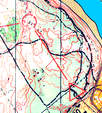
My route on the first leg probably cost me a few seconds. I was unsure of how thick the light green would be or how rocky the footing would be. On the way to the start, we passed some very rocky ground. A safe, conservative route to one seemed like a good idea. I kept running safe routes throughout the course. When I compared routes with some others on the same course, I noticed that everyone ran a number of trails. But, I seemed to run more trails than anyone else. The rest of my course is here. posted by Michael | 2:30 PM Thursday, October 09, 2003 Next update planned for October 14I'm leaving for Canada in a few minutes. Mary and I are running the "Great Lakes O' Festival." It should be fun as long as I remember to read the map.My next planned update will be Tuesday, October 14. posted by Michael | 10:38 AM Wednesday, October 08, 2003 Taking things for grantedWhen I was reading about the World Meeting I remember being surprised that I couldn't find the course online. The World Meeting took place last weekend in Sweden. Until this morning, I hadn't seen the courses on the Internet.This morning I found the courses at staff-valdstad.com. Here is the first part of the F21 course and here is the second part. I take for granted that I'll be able to look at the courses from international orienteering races. I shouldn't take it for granted. I should be grateful for how easy it is. When I began orienteering in the 1980s, getting results, let along maps, from international races wasn't so easy. I remember getting a U.S. Team News in 1983 within a few weeks of the WOC in Hungary and being psyched to see black and white photocopies of the courses. And now I'm annoyed if it takes a few days to find the color map online. In a comment a few days ago, Eric wrote: I think the online sources of maps deserve special mention in the context of map study. Great maps and courses are so much more accessible today. This is like a fantasy for me. Eric is right. Online maps are much more accessible today. And that is great. The Internet could -- and probably should -- make it easier for orienteers to prepare for events. That might just be a topic for another day...thoughts on how to use the Internet to improve your orienteering... posted by Michael | 1:03 PM Tuesday, October 07, 2003 Gunilla's strategyGunilla Svard won the "World Meeting" in Norberg, Sweden, last weekend after changing her race strategy.A newspaper wrote: "I have to thank Johan Ivarsson for today's victory. He shadowed me on a training course Thursday and helped me think differently," said Gunilla. Analyzing Gunilla's race shows that she started fairly easily and then increased her pace and held her concentration all the way to the finish. She took the lead at the 6th control. I took a quick look at the results and it looks like Gunilla started a little easy, but it isn't like she started slow. By ten minutes in to the race (four controls), she'd had leg placings of 10th, 1st, 11th and 2nd. She was 29 seconds out of first after the first leg (which took Gunilla just over 6 minutes. After ten minutes of racing, she was only a few seconds behind the leader. Maybe Gunilla usually starts a lot faster? More likely, the analysis in the newspaper wasn't done carefully. IF Thor's homepage has a story about Gunilla's race: Gunilla tried a different and more successful tactic last Saturday. In prior years she has, unfortunately, made too many booms when she's been distracted by other runners or started thinking about having good results. This time her place wasn't so important and she orienteered safely. She didn't even care when her result was first posted as a mis-punch, which was later corrected. posted by Michael | 1:38 PM Monday, October 06, 2003 A collection of O' mapsCheck out Oystein Kvall Osterbo's online collection of O' maps.Osterbo is on the Norwegian national team (the "NOM" group rather than the "WOC" group). He's got a nice variety of maps from all over Scandinavia and a few from continental Europe. It looks like some of the links aren't current, but there are still a lot of nice maps to study. posted by Michael | 9:10 PM Sunday, October 05, 2003 After the first week of my 30-minutes-a-day map study experiment I've got a few observations. My plan was to spend 30 minutes studying O' maps each day. I missed one day. I never got around to looking at a map yesterday. 30 minutes is a fair amount of time to spend looking at an O' map. I can't stay concentrated for the entire 30 minutes, so I usually break it up in two or three shorter sessions. I'm already noticing the effect of studying maps, or at least I'm noticing things that I wasn't before I began my map study experiment. When I was running on Thursday I was looking at the terrain and "picturing" how it would look on a map. I wasn't trying to do that. I just happened automatically. The same thing happens when I've been fieldchecking. Looking at old maps brings back some memories. I was looking at a map from a race I ran in 1984. I have very clear memories of some of the legs. Looking at the leg nearly 20 years later, I can remember deciding how to run the leg and what I used to navigate. My memories seem to be strongest from legs where I planned and executed the leg well. Some memories from old maps are gone. For the map from 1984, I don't have any memory of the weather or how I placed or who else was at the race or how I got to the event. I don't remember if the boulders on the map were large or small. I don't remember if the green was very thick or thorny. I'll continue studying maps for 30 minutes a day at least through this week. posted by Michael | 6:02 PM Saturday, October 04, 2003 Second day at the U.S. ChampsHere are a few notes about a few legs Tom was interested in...Take a look at the 6th leg. 
I remember looking at the leg and thinking, "that doesn't look like much fun." The climb wasn't steep. But, at altitude, I knew I couldn't run it. So, I walked. I don't really see any major route options. The green was generally pretty trashy. If you didn't follow the reentrant with the white forest in the first half of the leg I don't know what you'd do. I also don't see any very good ways to take the control. I don't see any good attack points near the control. I don't see any good way to simplify or extend the control. I contoured from a distinct part of the top of the ridge about 250 meters before the control. I looked below, hoping to see the reentrant and the shape of the hillside. As it turned out, the control wasn't hard to see once you got near it (it was a water stop and you could also look for the cups and people standing there drinking). Check out the 8th leg. 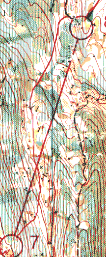
The trail to the right of the line jumped out at me. But, I don't see a good way to get there. I decided to use the white forest and reentrant to get me near the control. The control doesn't look especially difficult. Using the trail that goes northwest from the control made finding the circle very easy. I ended up losing a few seconds within the circle because I got hung up in some thick vegetation and didn't spot the flag as quickly as I should have. These two legs (6 and 8) have a very different character from the rest of the course. The two legs together add up to maybe 2.2 km, nearly 30 percent of the total course length. If you're interested, here is the map of the entire course. Finally, take a look at the 11th leg. 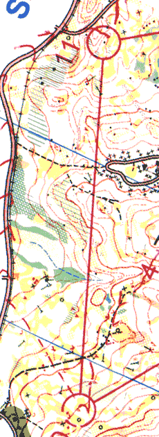
Here is what Tom wrote about this leg: I went to the road and was moving along. But some had some pretty quick times. I figure they must have run really hard or maybe went straight using the campground as an intermediate point. I haven't looked carefully at the split times for this leg, but I can't imagine straight is any faster than the road. James Baker went straight (and he's been running a little bit faster than me) in 7:42. I took the road in 7:14. On the other hand, Tom, who is a relatively fast runner, took 7:50 on the road route. Maybe Tom just loafed on the road. Or maybe he loafed in the forest on the way to the road. I don't know. posted by Michael | 9:48 AM Friday, October 03, 2003 New OrienteerCongratulations Sanna and Maggi.Check out Moa Wallenborg, the newest member of Orienteer Kansas. posted by Michael | 8:22 PM Thursday, October 02, 2003 Notes from a sprint raceNote to self -- In a sprint race, take a few extra seconds at the start and a few extra seconds at each control to make sure I'm going to the right place next.Here is a bit of Lars Skjeset's description of his run at a Norwegian sprint race (my translation is a bit rough): My suffering began on the first leg. I couldn't find the start triangle on the map immediately and searched a little (?) before I found the marker. Toward the second control I still hadn't gotten into the map and lost a few seconds. On the way to the next control I saw a chance to regain some of the seconds I'd lost. But, I must have been a bit too stressed and orienteered directly to the 7th control. When I got there and the code didn't match I was confused (?). I looked around for other controls in the little bit of forest. It took me a bit before I understood what I must have done. It sounds like Skjeset's race is a mess. When I looked at the map I had a lot of sympathy. It isn't easy to see the start triangle or to make sense of which control comes next. Take a look at the course and Skjeset's routes here. posted by Michael | 12:43 PM Wednesday, October 01, 2003 Marita on map studyMarita Skogum wrote a bit about map study in her book. She's describing her preparations for a World Champs. Two months before the race...Maps from WOC-like terrain are all over the house, in the bedroom, on the kitchen table, in the bathroom. You can't avoid them. I also have a map from a very good race. Studying that course gives me a positive picture of success. I remember how it looks and how it feels when everything goes just right. I need a lot of time to relax and study maps and to think about what will come in a few weeks.... Unfortunately, Marita doesn't say how much time she spent studying maps. I say "unfortunately" because I'm curious about how much time orienteers spend looking at maps. I guess I'll have to take a look at the rest of the book and check out a few other sources. posted by Michael | 8:35 PM |
|
||||
|
|
|||||