Occassional thoughts about orienteering
| okansas.blogspot.com Occassional thoughts about orienteering |
|
Thursday, October 31, 2002 next update will be MondayI'm going to the US Champs this weekend and don't expect to update this page until Monday.If you're sitting at the computer and looking for something to do, check out "googlism." Type in your name and see who you are. A googlism search for my name returns..."eglinski is the us champ" That's got to be a good omen! Who is Gagarin? You'll get a list that includes: gagarin is a towering figure for all times gagarin is dark while bykovsky is clearly seen gagarin is in the hospital to have his inflamed tonsils removed gagarin is often referred to as "the columbus of the cosmos gagarin is here gagarin is now involved in a dictionary fund gagarin is set to be removed from his pedestal and cleared away to a less obtrusive resting place Who is Mook? mook is what critics call the crude mook is a classicist and archaeologist whose research interests are late bronze age mook is like a gangster mook is 67 mook is excited about the relationship mook is one of the nicest we've seen in a long while mook is high quality and the pictures are crystal clear mook is fucking incredible mook is extermely dangerous mook is extremely aggressive What is orienteering? orienteering is a way of living orienteering is a good way to teach children map skills orienteering is an endurance sport attracting both orienteering and mountain bike enthusiasts orienteering is exciting as an end in itself orienteering is a sport of skill that teaches players how to read nature's clues orienteering is the skill of finding your way through a series of checkpoints on an unfamiliar course using a map and a compass orienteering is a relatively inexpensive sport orienteering is a sport orienteering is called 'sport for all' orienteering is not a part of life orienteering is usually done in the woods orienteering is now done on all inhabited continents orienteering is simply a canoe and kayak race with map and compass Try googlism for a few minutes of amusement posted by Michael | 1:30 PM Wednesday, October 30, 2002 5 thoughts before the US ChampsGoals My goal is to have two clean runs. Recently, I haven't managed to put together a good race. I put in a few good legs, then boom. At times I've navigated and run well...but only for a few legs at a time. I'm hoping to put together two clean runs. I don't expect to win, but I might be able to fight for a top 3 place.Yardstick This race should give me an idea where I stand. I'm not in the best shape and I'm not orienteering especially well. How will I stack up against the competition? The level of competition looks good -- orienteers like Joe Brautigam and Greg Balter are running M35 although they'd probably be competitive in M21. Nice courses? When Mary and I went to Peggy's wedding in June, we got her to design a couple of training courses for us. The training courses she designed were good -- plenty of variety and some tough controls. I'm looking forward to a weekend of good courses (Peggy is setting one of the days). Is this Mook's year? In the pre-race speculation on the Attackpoint discussion, Mook's name hasn't shown up. But, I think this is a race where Mook could shine. THe last time a strong field was assembled in this sort of terrain was at the short and long champs in 2001. That race was in Ohio. Mook dominated. He won both races. Cool map Ok, this has nothing to do with the US Champs. Check out the map from a recent Park World Tour race in Italy. This looks like really interesting stuff. posted by Michael | 9:32 PM Tuesday, October 29, 2002 Wrong way SpikeAntti's problem at Smalandskavlen reminded me of my own wrong way race at a race in Finland in 1988 (I think).Here is the map with my routes. 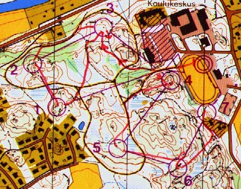
As you can see, I orienteered from the start almost to the third control before I realized what was up. Once I realized my mistake, I got back on track and had a reasonable run (small boom at 6). But the damage was done and I lost a lot of time. The race was the second part of a short distance race near Turku in Finland. The first part of the race had individual starts and covered 1.9 km. The second part of the race was a chase start over a 2.1 km course. I was pretty happy with my race for the first 1.9 km. I finished in 10:43, about two minutes back. Now, a minutes per kilometer behind doesn't sound good, but the field was very strong. The top three after the first course were Oyvin Thon, Oystein Haalo and Rolf Vestre (all Norwegian team members at the time). A minute per km behind those guys wasn't anything I was ashamed of. In the chase start I ran hard. Unfortunately, I obviously ran too hard to actually read the map and realize the first control was not the one I was heading to. As I approached the third control (thinking it was the first), I saw the three Norwegians approaching the same control from west. Wow, Oyvin Thon missed and I caught them! It didn't take more than a second or two to realize I probably hadn't caught the three Norwegians. I took a quick look, realized what was up and headed back toward one. I'm sure I learned a lesson that day. The race was really a lot of fun, despite my foolishness. Back in 1988, top level orienteering had only two types of races -- relays and what is now called "long distance" (aka classic). The chance to run a short race that was designed for spectators was really special. I just wish I'd taken it a few seconds slower in the first 100 meters. posted by Michael | 12:58 PM Monday, October 28, 2002 Wrong way AnttiIt sounds like a nightmare. You're running in a big relay race. After two legs, your team is leading and you're ready to go. You grab the map and go...but, you go the wrong way. You run the course backwards. Instead of starting with 1, 2, 3, and so on, you run to 14, then 13, then 12...Antti Harju lived the nightmare at this weekends Smalands Kavlen in Sweden. He went out in the lead and ran the course the wrong way. Apparently he discovered his error when he met, head on, the pack that had gone out behind him. To his credit, Antti ran back to the first control, then the second and so on. He finished the course. His time was 95 minutes, compared to a best time just under 48. He went out in the lead and finished in 128th place (of about 190 teams). posted by Michael | 12:50 PM Sunday, October 27, 2002 Low quality trainingToday's training was the sort of training that I really don't need. Platt and I jogged around a course on an O' map. We didn't really pay much attention to what we were doing (not to mention that Platt was singing some of the time). You don't really get much out of this sort of training. I'd call it very low quality O' practice.5 things to do to make O' practice high quality Concentrate on what you're doing. O' practice if you're not concentrating on orienteering isn't much use. Jogging along and chatting isn't the best way to spend time on a map. Have someone else design the course. This makes it feel more like a real race and forces you to deal with the O' problems in a way that you can't if you designed the course yourself. Run at a race effort. O' is about navigating while you're running hard. Training at a hard effort raises the quality of the session a bunch. I don't think running with a heart rate monitor is essential, but it can help. Use controls. Running to controls instead of to a feature simulates a race. Of course, getting the controls out there isn't always so easy. The best solution is to get the club to organize training sessions -- different people taking responsibility for setting the courses and hanging markers each week, for example. Try to make it feel like a race. Think about the stuff that you do at a race and do that at a training. That might include giving yourself a specific start time and warming up the way you would at a race. posted by Michael | 6:29 PM Saturday, October 26, 2002 Music in my headI had a song stuck in my head for the first part of today's O' race at Burr Oak. Usually that means I'm not paying attention to what I'm doing. After about the first leg, I was paying attention to orienteering and the song wasn't stuck in my head any more.What song was it? "Do You Know How It Feels" is IFK Lidingö's Jukola song (downloaded as an MP3 and transfered to a CD so I can listen in my car). Want to have it stuck in your head? Download the mp3 of "Do You Know How It Feels." posted by Michael | 4:04 PM Friday, October 25, 2002 More on relevant terrainI've written (and tranlated) some stuff about relevant terrain on Okansas in the past. Here are some links:Jimmy Birklin and the Swiss WOC terrain. Is Portland terrain relevant? Where should the 2003 WOC team be selected? Lasse Hogedal on preparing for the 1991 WOC in Hungary. Mapsurfer is back!!! Randy went to the World Masters O' Champs in Australia and just got home. His page is always worth looking at and is especially interesting now as he recounts his adventures in Australia (with links to maps and routes). Check out Randy's O' log at Mapsurfer.com. posted by Michael | 6:03 PM Thursday, October 24, 2002 Relevant?I bumped into a discussion on the US Team yahoo group about the team trials for the 2003 WOC in Switzerland. Reading some of the messages made me think about what we mean when we talk about an area being "relevant." One of the messages gave scores to several options (using a 1-5 scale) that included:Terrain Relevance/Challenge - Is it like the Swiss WOC terrain? Is it at least reasonably navigationally challenging? Event Length Relevance - The goal here is one ‘middle-distance’ day (30 minutes winning) and one ‘classic/long’ day (60-75 minutes winning). Frankly, I don't think it makes much difference where the US selected the WOC team because the better orienteers in the US are likely to rise to the top regardless of terrain. How do we decide what is relevant? I think it is interesting to consider what we mean by "relevant." Even if you're not interested in running in a WOC, it can be useful to prepare for any race by thinking about the characteristics of the area. If you goal is to finish the Possum Trot, it is worth spending some time thinking about what would be "relevant" terrain for preparing for the Possum Trot? I haven't spent much time organizing my thoughts, but some of the questions I'd ask myself when I'm thinking about relevance: 1. What type of leg/control is likely to be hard in this terrain? 2. Are the places where a leg will be difficult in the middle of the leg? 3. How far will you be able to see in the forest? 4. Is the footing rough, smooth, soft, hard, rocky, etc.? 5. Are there "social" stresses? For this year's Possum Trot, I can begin to answer these questions. 1. Controls that will be hardest are either point features in green areas (which we can hope the course setter doesn't use!) or controls where you cross a flattish ridge top and have to go down into the correct reentrant on the other side of the ridge. 2. The problem in the middle of a leg at the Trot will probably be to keep a high pace and hold concentration. I don't foresee any especially difficult navigational problems in the middle of legs, but I can imagine losing time if you're mind wanders. 3. It should be possible to see a long way in the forest. This means you may be able to see markers and features from a long way away. It might also make it tougher for another runner to get away (or for you to lose someone who is following you). 4. The footing will be typical of the KC area -- a few areas with loose rocks, some areas with downed trees and some areas with un-pleasant underbrush. Green areas might have thorns. 5. It is a long distance race with a mass start. Going out too hard will cost you. It'll be easy to get caught up running too fast. You'll probably be faced with decisions like -- do I push the pace a bit to stay with this guy and risk bonking or do I let him go and hope he bonks? The weather in December is likely to be cold and could easily be cold and wet. Back to Switzerland... Preparing for a WOC is interesting and in some ways a lot more difficult than preparing for the Trot. But, the process -- asking and answering questions -- is basically the same. One real difficulty in Switzerland (something I've written about before) is the huge variety in terrain and races. The sprint race is a street O' event on a 1:4,000 map with 2.5 meter contours. The winning time for the sprint is 12 minutes. The long distance races (qualifying and final) are in a terrain with steep slopes and deep valleys. The maps are 1:15,000 with 5 meter contours. The men's qualifying should be won in 60 minutes and the men's final should be won in 90 minutes. The middle distance qualifying and finals are in another type of terrain -- an ancient landslide covers the area and leave it with complex contours and some boulders. The maps are 1:10,000 with 5 meter contours. The winners will be running for about 25-35 minutes. Finally, the relays are in terrain that seems to be most similar to the long distance event, but with some other features (like some sandstone). The challenge in thinking about relevant terrain for the Swiss WOC is obvious -- there isn't a single relevant terrain. The differences in terrain (from street O' to complex contours) is tremendous. posted by Michael | 8:27 PM Wednesday, October 23, 2002 More on map scalesI was poking around Tore Sandvik's newly released web site and came across some discussion of map scales at the World Cup race in Belgium.* Since I wrote about map scales recently (October 15), Sandvik's discussion caught my eye.Here is a quick (and rough) translation: The middle distance qualifying race (3,710 meters, 125 meters of climb, 11 controls) was in terrain where the courses went around and over a moraine covered with a mixture of hardwood and spruce forest....Both the courses and terrain were good, and except for the map being at a scale of 1:15,000 and printed in four colors, the map was good. That the IOF decided to use a scale of 1:15,000 instead of 1:10,000 on that map was a scandal....That the IOF chose a scale of 1:15,000 for the map [for the final of the middle distance] wasn't as hopeless, but it is still a scandal that they use anything other than 1:10,000 for a middle distance race. You can see the map on the web (though you can't really tell how it would look printed at 1:15,000 with four color printing) at the organizer's web page. Check out the page with route choices. Poking around a bit more, I found a scanned copy of the map . It copied the image onto my computer and resized the image to try to get it to look like a 1:15,000 map (adjusting the image so the distance between the magnetic north lines is 500 meters at 1:15,000). Doing that makes the map quite difficult to read (though it isn't really a fair way to assess the actual competition map). At least one regular reader of Okansas ran the Belguim World Cup. Kenny, any thoughts about the map and scale of the middle distance qualifying race? *If you're not familiar with Tore Sandvik, let me give you a bit of info. He's on the Norwegian national team and runs for Halden SK. He got two silver medals at the WOC in 2001 and won a gold in 1999. posted by Michael | 7:50 PM Tuesday, October 22, 2002 Staff-Valstad is another winner!No surprise: Staff-Valstad is the winner of an Okansas prize for non-English O' web site.Why is it cool? Great content makes for a great web site. Great content. Hanne Staff and Bjornar Valstad are two of the best orienteers in the world...and they update their web site regularly. Even if you can't read Norwegian, you can enjoy the site. There are lots of photos (click on "bilder") and maps (click on "kart fra konkurannser") to look at. Could it be even better? I can't think of any obvious ways to improve the page. Staff-Valstad could reach a bigger audience if it were in English. But, I'd rather see more content in Norwegian than less content and English. What they really need is for some dedicated volunteers to translate select articles -- that way they could still have a lot of content and frequent updates, without having to devote time to writing in English. posted by Michael | 7:39 PM Monday, October 21, 2002 Attackpoint is the first winner!Attackpoint is the first winner of an Okansas Prize for English language O' web site. Congrats to Kenny Walker, Jr., who created Attackpoint.Why is it cool? Attackpoint is cool because it has created a little community -- people who log their training time and racing. I take a look at it almost everyday when I add my training. I usually make a point of checking out training of a couple of other people, too. Over time, you feel like you get to know some of the other people, even though they live far away. When you bump into those people at an A-meet, you know what they've been up to. As you read other people's training logs, you begin to feel the thrill of their victories and the agonies of their defeats. I like to check out: Kwalker, PG, Nadim, biggins, ebuckley, ebone, Vladimir, BorisGR, Hammer, Mean Gene, Ashley, Suzanne, and...well, just about anyone else. Could it be even better? I'm not sure it could be better. Attackpoint is pretty good as is. It might be cool to have something like the Runoway feature from Alternativet. Runoway lets people draw their routes on maps from selected races. It is very cool, but hardly necessary. Recently, more and more Attackpointers are scanning their race maps and putting links from their training logs, for example, here are Boris' routes from last weekend and here are Peter's routes. It'd also be good if people wrote more about their plans and goals. Attackpoint lets you enter comments in your training log. That'd be a good way to describe plans and goals. Few people use the comments very much. posted by Michael | 7:29 PM Sunday, October 20, 2002 Nice contoursKnob Noster is probably the best orienteering area around Kansas City. The forest is relatively open, while most of our terrain is thick and thorny. The map has a nice mix of forested hillsides, floodplain and developed areas.The only problem with the area has been that the contours weren't well mapped. The basemap showed a lot of contour detail, but it didn't quite show it correctly. When the map was first fieldchecked, the fieldcheckers apparently didn't change the contours. I revised the map in the late 1980s, but I didn't do anything with the contours (not because I thought they were fine, but because the time budgeted to update the map wasn't enough to cover the whole map and update contours). The contours were always useable. In fact, a lot of fine detail was shown, it just wasn't shown in the detail you'd like to see. You could always find a lot of small reentrants that were shown on the old map, but the specific shape of each reentrant wasn't shown properly. The map was useable because it was consistent, but it left a lot to be desired. Now the map has been updated and the contours fixed! Thanks to Fema, we've got a really nice map. I'm hoping that some of the local mappers will have a chance to spend some time at Knob Noster to really see how contours can -- and should -- be mapped. Mary and I ran there yesterday and it was a real pleasure. The only problem is that the forest has gotten a bit thicker and thornier. It remains the most "pleasant" area around Kansas City for orienteering. The map below shows a small clip of the old map and the new map. Notice how much more contour detail is shown on the new map. 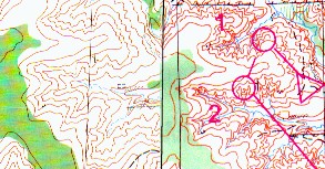
The first official use of the Knob Noster map will be this year's Possum Trot the first weekend of December. posted by Michael | 6:33 PM Saturday, October 19, 2002 What did Valstad have to say about his World Cup win?Bjornar Valstad not only won this year's World Cup for men, he also wrote about it on his web site. I translated a bit of what he wrote. You can find my translation at:Some thoughts from the World Cup winner Please note that my translation is a bit rough (my Norwegian is much rougher than my Swedish). My appologies if I've misunderstood what Valstad wrote. posted by Michael | 12:11 PM Friday, October 18, 2002 Olympic snapshotIt has been a good eight months since the Olympics in Salt Lake City. I was looking at some of the photos I took at Soldier Hollow. This snapshot shows the last leg skiers for the Norwegian and Italian teams on the last bit of the last uphill before they entered the ski stadium to sprint for the finish. It was a great race. The Norwegian (I think it is Thomas Alsgaard) just managed to edge the Italian (Forzi?) for the gold.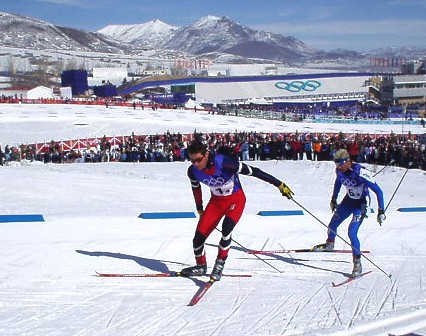 posted by Michael |
8:09 PM
posted by Michael |
8:09 PMThursday, October 17, 2002 The Okansas PrizeI've been inspired by the recent Nobel Prize announcements to create the first okansas prizes.I plan to announce the first winners within the next week or two. Until then, I'll be accepting nominations (use the comment function or send me an email at meglin@juno.com). The categories are: Orienteering web site (I'll probably have categories for English and non-English sites). Other web site. O' event (event is broadly defined, it could be a training camp, a race, a party or something else). Product (something you can buy). Special achievement (a prize for anything that doesn't fit one of the above categories, but is still worthy of the glory of receiving an okansas prize). The selection committee has one member -- me. I'll probably run my selections by Mary before making them official, but I have the final say. There aren't any specific criteria, but I'll try to make sure I have some reason for selecting each winner. posted by Michael | 7:51 PM Wednesday, October 16, 2002 My magnifierWhat kind of magnifier do you use? Where did you get it?I use a Silva magnifier. I bought it at the Swedish 5-days last summer. I'm not sure if anyone in the US sells the model I use. Joe Scarborough and Gale Teschendorf both sell thumb compasses with magnifiers that look quite nice (as long as you use a thumb compass, that is). This photo shows how I use the magnifier with the compass. I use a compass that sits on an elastic band around my wrist. The magnifier fits over my thumb. 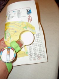
The problem with the magnifier is that it makes it difficult to see an entire leg. It is easy to see the bit of the map under the magnifier, but if the leg is longer than the width of the glass, the magnifier obscures part of the leg. On longer legs, this can be a real pain. If the magnifier is on your thumb and you move it off the map, you can't keep your thumb on the map to mark your location. When I want to look at the map without the magnifier -- for example, to look at a long leg or when I don't need the magnification to see the details -- I slip the magnifier off my thumb and put it on my middle finger. My middle finger is on the bottom of the map as I run. This photo shows it. 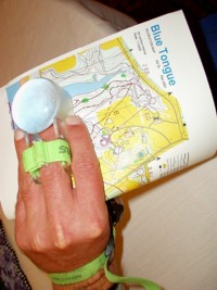 posted by Michael |
8:21 PM
posted by Michael |
8:21 PMTuesday, October 15, 2002 Map scales - 1:10,000 v 1:15,000The Southern Michigan A-meet used 1:15,000 maps for the blue and red courses and 1:10,000 for all other courses. The maps appeared to be color copies of ink jet prints.Comparing the two versions of the maps was startling. The 1:10,000 maps were much more readable. Some features were much easier to read on the 1:10,000 version. For example, the small tick marks on depressions stood out clearly on the 1:10,000 map and were difficult to see on the 1:15,000 map. I asked some of the SMOC members why the blue course didn't use a 1:10,000 map. They said that USOF either told them they couldn't or suggested that they shouldn't. I'm not sure who "USOF" would have been - maybe the sanctioning committee or maybe the course consultant. I wish we'd had the 1:10,000 version of the map and I can't understand why a 1:15,000 version would be preferable. I discussed map scale with a few people at the meet and got a few lame arguments for 1:15,000: 1. A 1:10,000 map is too big a piece of paper -- it is hard to carry. That seems a bit ridiculous. You can always fold the map in half (don't blue course runners know how to fold the map?). At SMOC the blue courses could have been printed at 1:10,000 on an 8 1/2 x 11 inch piece of paper. I've never heard people complain that a 1:15,000 map is too big. We've orienteered on some big pieces of paper: Silvermine and Surebrigde Mountain are good examples. Have people complained that the paper is too big? 2. Using a 1:15,000 map is good because top elite races use 1:15,000 maps. The concept seems reasonable....except it isn't correct. The last WOC used maps at 1:10,000, 1:5,000 and 1:15,000. The European Champs used maps at 1:5,000, 1:10,000 and 1:15,000. The top elite races force competitors to use different scales in a relatively short period of time. 3. Some people have difficulty adjusting to "different" scales (i.e. if they're used to 1:15,000 then it is hard to use 1:10,000). I'll buy that it might be true. But, it doesn't seem like a good reason to stick with a specific scale. 4. 1:10,000 maps are over detailed because the mapper squeezes too much detail into the map. The level of detail is more a function of the scale the fieldchecker works at than the scale the map is printed at. Maps fieldchecked at 1:7,500 or 1:10,000 aren't usually over detailed. 5. Course setters tend to set fewer long legs on 1:10,000 maps than on 1:15,000 maps. That's finally an argument I buy (at least a bit). To me, the harm of fewer long legs is less than the harm of making it hard for orienteers to read the map. The argument for using 1:10,000 seems stronger -- the map was much easier to read at 1:10,000. Orienteering is about using the map to navigate. It shouldn't be about testing eyesight and individual abilities to make educated guesses about features that aren't clearly shown. I don't think I suffered from the 1:15,000 scale map. I carried my magnifier and was able to read details fairly well. In fact, the hard to read map probably helped me (because I carry a magnifier). If the map had been offset printed, 1:15,000 would have been fine. But, it wasn't. Maps printed on ink-jet printers are not as easy to read as offset printed maps. posted by Michael | 7:46 PM Monday, October 14, 2002 Some maps from MichiganOne the first day, we had a strange leg -- 12-13 was a road run around a gravel pit. (Sorry about the poor scan). Given the interesting terrain the course setter had to work with, I don't understand why the courses went through this part of the map.
The second day had some much more interesting legs. Here is an example: 
13 to 14 violates a couple of the normal guidelines for courses, but is still an interesting leg. One "flaw" is that there is a huge catching feature just before the control (the road). Another "flaw" is that one of the possible routes to the next control is to come out of 14 heading south, making it a "dog leg." Still, I think it is a good leg. You've got a couple of options. You could run the roads to the left or you could go straight. Straight looks faster, but is clearly more difficult. On the straight route, you've got to pay attention to avoid unnecessary climb. I took the straight route. Check out the entire day two blue course. I think it is a good course. There are plenty of direction changes. The course runs through several distinct types of terrain: the flat area around 3 through 7 (an abandoned golf course); the marshy area around 7 through 9 and 15 through 17; and the relatively hilly areas with trails and roads (the rest of the course). I found the day two course interesting and challenging. posted by Michael | 6:58 PM Course setting in MichiganThe blue courses in Michigan were remarkably different. Two different people set the courses, so some differences are to be expected. But, my impression was that the two course setters had very different approaches to designing a course.The overall shape of the courses was different. On day one, we made a general counterclockwise loop around the map. On day two, the course looped over itself several times. The amount of terrain used each day was different. On day one, we used a fairly large portion of the map. But, on day two, the entire blue course fit in are area of less than 3 square kilometers (and the day two course was over one kilometer longer). The "pleasant-ness" of the terrain was different. On day one, we spent a fair amount of time in thorns and green. On day two, we spent much less time in thorns and much less time in green (though the woods were still fairly thick and we had options to run through some fairly dense marshes). One control on the first day involved forcing you're way through some fight at the edge of the map in a section of the map that was sketchy. From leaving the attackpoint (a junction between a trail and an erosion gully) to finding the control about 100 meters away, I took about ten minutes. I walked. I used a compass. I tried to read the contours. I had to bail out twice. I finally just began wandering and bumped into the control. The control placement was very different. On day one we had some markers that were hung so that it was tough to find the bag -- even when you got near the feature. On day two the controls were generally quite visible. The course setting trade-offs were different. On day one, we made a big loop around the map, but had a long road run to get around a big gravel put/concrete factory. There was only one way around the gravel pit -- along a dirt road. On day two we ran through a couple of areas more than once (the course crossed itself), but pretty much had to read the map the entire way. I preferred the day two courses. I should say, I preferred the day two courses much more. I think the difference in the courses reflect different ideas about the nature of our sport. The course setter for the first day likes orienteering to be about having a difficult time finding the marker. The course setter for the second day likes orienteering to be about making decisions throughout the race. I suspect that the day two course setter, Al Newman, began by looking at the terrain and picking the sections of the map he wanted to use. Then he probably designed a couple of longish legs with some interesting routes. He also saw a couple of areas that looked interesting -- in particular a flat area that was an abandoned golf course -- that he wanted to make sure the courses used. Finally, he looked for ways to connect the long legs and get the runners to go through the interesting areas. I think Al used the terrain quite well. I'll try to scan the course when I get home tonight and post it for all to see. posted by Michael | 1:17 PM Sunday, October 13, 2002 Coming attractionsI'm not up to writing this evening, but I'll give you a preview of Southern-Michigan-A-meet-inspired topics that I'll write about in the next couple of days:1:10,000 versus 1:15,000 maps Course setting Look for more in the next day or two. posted by Michael | 7:20 PM Friday, October 11, 2002 Next update will be MondayI don't expect to update this page until Monday (because of the trip to Michigan). There is a chance I'll add a note Sunday night. posted by Michael | 11:54 AMThursday, October 10, 2002 Michigan A-meet thougthsFive thoughts about this weekend's A-meet in Michigan:Read the map That's my strategy -- read the map, let the running take care of itself. Old man on Blue I'm running blue. I'm not really in shape to run blue. But, I entered a month or so ago when I was coming into decent form. Since then, I've struggled with illness and feeling a bit out of it. Still, running blue should be fun. Since I tore up my knee/leg last year, I've been wondering if Pawtuckaway would be my final blue race. I didn't really want my final blue to end up with me being carried out of the forest and sent to the hospital. If nothing else, finishing the blue course at Michigan will feel like an accomplishment. The terrain should be fun I've probably done a dozen or so A-meet days in Southern Michigan. I like the terrain. The terrain is generally pretty flat, but with some interesting contour features. The contours are typically rounded and there can be some interesting low knolls and depressions. The forest is generally pretty runnable and the footing is good (very few rocks). There are typically some uncrossable water features that can help make for interesting route choices. Weather The forecast calls for warm on Saturday and cool and rainy on Sunday. I'd much rather run two days in a cool rain. Good company Four OKers are travelling together to the meet: Mary, Dan, Terhi and I. Shifman will be there. I don't know of any others. posted by Michael | 9:39 PM Wednesday, October 09, 2002 The new car...If you're a very dedicated reader of this web page, you'll remember that I've been in the market for a new car. Well, tonight I picked up the new car.Would I go with a Subaru Forrester or Outback (like the Brautigams and Gagarins)? Or maybe the very cool new Mini? In the end I got the Toyota Matrix. The Matrix is really a Carolla station wagon (I guess the name "matrix" sells better than "wagon"). I went with the two wheel drive because I didn't really see a need for four wheel drive around Kansas City. Buying a new car was a new experience for me. It wasn't especially fun. But, I suppose it could have been a lot worse. It was interesting to watch the sales people use their methods to try to get you to buy something you didn't need or want to pay for (like alloy wheels). I'm glad resources like USAA and the Kelley Blue Book are available. posted by Michael | 8:53 PM Tuesday, October 08, 2002 Spiking controlsThe training log at Attackpoint let's you enter the number of controls you found and the number you spiked.I looked at all the current entries to see how often people say they've spiked controls. Here are the hit rates (percent of controls spiked) for the last week: 90, 78, 65, 86, 84, 92, 83, 66, 78, 89, 91, 90, 79, 100, 69 and 92. The average of those numbers is 83. I don't usually count spiked controls. But if I did, I'd probably spike about 30-40 percent. I must: (a) Be a much worse map reader than most people at Attackpoint, or (b) Use a different definition of "spike." I suspect (hope) the answer is (b). It looks like people are considering a control as "spiked" if it isn't a boom.** To me, a control isn't a spike unless it is almost perfect. I've got to have good "flyt" and not hesitate. In most cases, I'd have to see the control (or the feature and know the control was at the feature) from a long way away -- as soon as reasonably possible -- to consider a control a spike. By my definition, I can have a control where I don't lose any time, but I don't consider it a spike. I guess I really have three ways of grading a control -- a spike, a boom and something in between. "Something in between" is quite common and is reasonably good; perhaps even as fast as a spike. But, "something in between" isn't as good as a spike. I need to come up with a better name than "something in between." ** By the way, the Finnish term for boom is "pummi." posted by Michael | 6:53 PM Monday, October 07, 2002 CoachingA while ago I wrote a bit about orienteers using coaches on the Attackpoint discussion board. The message is basically that coaching can be useful.Recently I came across a web page run by an amateur x-country skier named Mike Muha. Mike wrote some of his own thoughts and experiences of coaching. Take a look at: I hired a personal coach and A talk with Torbjorn posted by Michael | 8:40 PM Sunday, October 06, 2002 Local O' season is officially underwayThe local O' season started today. PTOC hosted a 2-hour score O' at Shawnee Mission Park.PTOC hosted a 2-hour score O' at Shawnee Mission Park in the spring. They didn't use all the maps they pre-printed, so instead of a new course, they just re-used the same course from the spring. Not the best, but I won't complain. I appreciate the work they put into putting out the markers. I remembered most of the controls from the spring. But, the terrain is different enough at this time of year, that I took a lot of different routes between the controls. In the spring the woods are much more open and you can see further. You could run straighter and a bit rougher near the controls. With the leaves still out, routes that went further out of the way seemed better. With the leaves out, you couldn't see very far and it paid to be a bit extra careful in the circle. I am not thrilled with how I ran. I started at a pace I figured I could keep up for nearly two hours. After about 65-70 minutes I slowed a lot. It wasn't hot, but it was warmer than ideal. That probably played a part in how I felt. Of course, I haven't really trained much in the last year -- so I probably shouldn't have expected to feel good for the entire run. I shouldn't have expected to have a good sense of pace. I haven't trained in the terrain much (you can't really get in the forests around here during the summer) and I probably suffered a bit because of my relatively weak woods-running form. Terhi bashed around in the woods for over two hours. She seemed to have fun, but she didn't say she liked the terrain. I guess most people don't like running in thorns. posted by Michael | 7:28 PM Saturday, October 05, 2002 DQAfter some O' training at Clinton State Park, Terhi, Mary, Dan and I ate ice cream at Dairy Queen in Lawrence. posted by Michael |
9:40 PM
posted by Michael |
9:40 PMFriday, October 04, 2002 20 years of changeHow has international O' changed in the not-quite-20-years between the 1983 WOC in Hungary and the 2002 European Champs in Hungary?I think there are three big changes: more variety (lengths and terrain types), a longer season and more strong nations. More variety In 1983, the WOC had two events -- a classic (with a qualifying race) and a relay. In 2002, the European Champs had a sprint, middle, long and relay. The individual races all had qualifying races. The top orienteers in 2002 either have to be able to prepare for a wider variety of demands or they need to specialize. World Class orienteers are also racing in a lot of different types of terrain compared to 20 years ago. In 1983, a world class orienteer could prepare themselves by thinking and training for a type of continental terrain in Hungary. But, in 2002, a world class orienteer was racing in everything from extreme central European continental terrain to Nordic terrain to street/park O' terrain. Longer season In 1983, a world class orienteer might focus on the WOC week. There was no World Cup, for example. In 2002, a world class orienteer could easily plan to race the Park World Tour, World Cup and European Champs. The European portion of the Park World Tour season began in May and ends in October. The Asian portion of the Park World Tour is in November. The World Cup ran from June through October. The European Champs was a week in late September. More strong nations When the USSR split up, the O' world suddenly got a bunch of new nations that have some very strong orienteers. In 1983, the USSR didn't have a team at the WOC. It wasn't until 1987 that the USSR had runners at a WOC. In 2002, the European Champs had runners from countries that had been part of the USSR: Lithuania, Belarus, Ukraine, Estonia, Russia and Latvia. What hasn't changed? I'm not as sure about what hasn't changed. My guess is that the course setting and map quality haven't changed much. I suspect that the top runners are training about the same (though I think there are more runners training really well now than in 1983). posted by Michael | 7:47 PM Annichen back in the "amazing" categoryEric W. checked out yesterday's posting and wrote:I just did some homework and found some weirdness. I measured this year's women's course on the '83 map and came up with ~6.9km, not the 8.5 km posted "prelim" distance. Using the same method the '83 course actually clocked in at 8.3+km. Check my work? This seems to put Annichen K. back in the "amazing" category. I haven't measured the courses, but I'm pretty sure Eric is right. Maybe someone will measure all four courses, recalculate the minutes per kilometer and post the results as a "comment." I should have been suspicious of the calculations. How could Annichen be that much slower than Luder? Annichen was a very strong runner who trained a lot. Back when she was at her best, she ran a road marathon in 2:40. How could Annichen be that much slower than Luder? The obvious answer is that the calculations (or the inputs to the calculations were wrong). When Dave Linthicum did the USOF rankings, he used to remeasure the courses at all of the A-meets. The advertised distance was rarely correct. posted by Michael | 12:47 PM Thursday, October 03, 2002 Then and now...Having the 1983 World Champs and the 2002 European Champs in the same place lets us do some interesting comparisons.Morten Berglia was nearly as fast in 1983 as Buhrer in 2002. Vladimir notes that Berglia ran 6.898 mins/km and Buhrer ran 6.78. Berglia's time is about 7 seconds per kilometer slower.** Annichen ran much slower in 1983 than Luder did in 2002. Vladimir notes that Luder won at 6.12 min/km while Annichen won at 8.46 min/km. Luder ran faster than Buhrer -- by about 45 seconds per kilometer. That's quite fast. I'm not sure, but I think it is quite unusual for the women's race to be won at a faster pace than the men's race. What is going on here? I think the difference between Berglia and Buhrer is inconsequential. In 1983, Berglia ran a longer course on a hotter day. The difference between Luder and Annichen is huge, but perhaps not quite as huge as 2:20 per kilometer might seem. In 1983, Annichen ran a somewhat shorter course, but the course was hillier and the weather hotter. Still, the difference is big. It would be interesting to compare courses from 1983 and 2002 -- are there any big differences in the course setting. Looking at the winner's times, it looks like the women in 2002 are much stronger than the women in 1983. That becomes especially apparent when you realize that Annichen won by over 7:30 while Luder won by just over a minute. Looking at results from 1983 and 2002, one thing that stands out is how much tighter the competition has become. In 1983, the tenth place man was about 45 seconds per kilometer slower than the Berglia. But, in 2002 the tenth place man was only about 17 seconds per kilometer slower than Buhrer. In 1983, the tenth place woman was about 1:18 per kilometer slower than the Annichen. But, in 2002 the tenth place woman was only about 18 seconds per kilometer slower than Luder. Looking at just these two races and leaping to some general conclusions.... The men aren't faster now than 20 years ago, but the fields are stronger. The women are much faster now than 20 years ago and the fields are stronger. ** Note: I'm doing most of the math in my head and not double checking it. I may have made some errors! posted by Michael | 1:40 PM Wednesday, October 02, 2002 A few thoughts from BjornarBjornar Valstad tied for second at the European Champs long (aka classic) race.Check out the map with Valstad's routes. I translated some what he wrote on his homepage:* Even though the results so far at the European Champs have been disappointing, I felt good before the start of yesterday's race. The classic distance is my best and my form felt good (even though the results from earlier races might suggest otherwise). My race was good, but I'm still making too many mistakes to be able to fight for the gold. I was in the lead at the 11th control, but then I boomed a minute.... I've been losing between two and three minutes on booms. That isn't good enough. I probably don't deserve a gold. But, it felt good to have flyt in my technique and to be fighting in the top again. The map from Hungary looks interesting. The area is very close to the area used for the World Champs in 1983 (the qualifying race for this year's classic used an area that was used in 1983). The terrain looks "neutral" to me. By neutral I mean not extreme -- not super-detailed nordic terrain or extreme continental terrain. It looks like there was a lot of trail running (at least by Valstad). In looking at his route, I only see one leg (7-8) where a trail route looks decent but Vladstad didn't use trails. The women's course doesn't seem to offer as much trail running. Certainly Hanne Staff -- her routes are shown -- ran much less of her race on trails than Valstadt did. * My Norwegian is a bit rough, so I may have missed something in what Bjornar wrote. My apologies if I did. posted by Michael | 8:20 PM Tuesday, October 01, 2002 What if you took spam seriously?What if you took your email spam seriously? What would you have been doing today?I would have: 1. Made lenders compete to give me money. 2. Met female parolees who "wanna do it." 3. Suscribed to Outside magazine AND got a free gift. 4. Played matchmaker for my single friends. 5. Watched sailboat racing on TV. Surprisingly, I didn't get any offers to buy viagra online or earn big money...maybe next time I check my email.... What would you have been doing? Let me know using the comment function. posted by Michael | 9:15 PM |
|
||||
|
|
|||||
