Occassional thoughts about orienteering
| okansas.blogspot.com Occassional thoughts about orienteering |
|
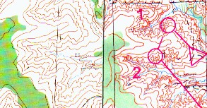
Sunday, October 20, 2002 Nice contoursKnob Noster is probably the best orienteering area around Kansas City. The forest is relatively open, while most of our terrain is thick and thorny. The map has a nice mix of forested hillsides, floodplain and developed areas.The only problem with the area has been that the contours weren't well mapped. The basemap showed a lot of contour detail, but it didn't quite show it correctly. When the map was first fieldchecked, the fieldcheckers apparently didn't change the contours. I revised the map in the late 1980s, but I didn't do anything with the contours (not because I thought they were fine, but because the time budgeted to update the map wasn't enough to cover the whole map and update contours). The contours were always useable. In fact, a lot of fine detail was shown, it just wasn't shown in the detail you'd like to see. You could always find a lot of small reentrants that were shown on the old map, but the specific shape of each reentrant wasn't shown properly. The map was useable because it was consistent, but it left a lot to be desired. Now the map has been updated and the contours fixed! Thanks to Fema, we've got a really nice map. I'm hoping that some of the local mappers will have a chance to spend some time at Knob Noster to really see how contours can -- and should -- be mapped. Mary and I ran there yesterday and it was a real pleasure. The only problem is that the forest has gotten a bit thicker and thornier. It remains the most "pleasant" area around Kansas City for orienteering. The map below shows a small clip of the old map and the new map. Notice how much more contour detail is shown on the new map. 
The first official use of the Knob Noster map will be this year's Possum Trot the first weekend of December. posted by Michael | 6:33 PM
Comments:
Post a Comment
|
|
||||
|
|
|||||