Occassional thoughts about orienteering
| okansas.blogspot.com Occassional thoughts about orienteering |
|
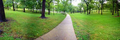
Sunday, August 27, 2006 Yesterday's sprint race at LongviewMaps from yesterday's sprint race at Longview Lake.The course was tougher than it looks on the map because the light yellow (rough open with scattered trees) was very rough. You couldn't hold a straight line through the light yellow. Actualy, you probably could, but it would have involved running through some unpleasant thorns and massive amounts of poison ivy. Snapshots from mapping project I'm working on a sprint map of the KU Campus. I planned to get in several hours of work today, but I only managed a bit over an hour because of a lot of rain. I took a couple of snapshots that illustrate some of the terrain. I think it'll make for fun sprint orienteering. The start will be near Marvin Grove, a small area of big, old trees.  The campus also includes areas with lots of buildings, stairways, low walls (high walls, too), and gardens. This snapshot shows the Anschutz Library on the far left, with Budig Hall and the stairways between Budig and Wescoe. I think this sort of area will allow for some tricky control placements and route choices.  I made these two panoramic photos using a very slick software called Autostitch. The snapshot of Marvin Grove is 8 individual pictures stitched together. The snapshot of Budig is 3 individual pictures stitched together. Stitching the images together was amazingly simple. You just open the files the go together and click, Autostitch puts the photos together automatically. It is almost like magic. posted by Michael | 7:06 PM
Comments:
Post a Comment
|
|
||||
|
|
|||||