Occassional thoughts about orienteering
| okansas.blogspot.com Occassional thoughts about orienteering |
|
Monday, May 03, 2004 Some West Point notesInstead of scanning my routes and writing up the event, I decided I'd just write about a couple of controls.
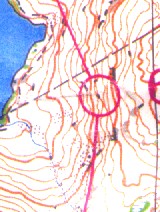
As I approached the 9th control on the first day (above), I looked for the large cliff about 100 meters before the control. As I glanced at the map, it looked like staying below the cliff would take me right to the control. The control itself is at the foot of a little cliff. I went by the big cliff and expected the small cliff with the control to be easy to see. I stopped and headed down hill a bit and took the control. At the time, it felt like I had gone too far down the hill to get the control. I thought the map might be a bit off or the control might have been hung on an unmapped cliff (there were parts of the map where there fieldchecking was a bit sketchy). When I finished, I heard some other runners complaining about the 9th control being hung wrong. They said it was too far down the hill. When you looked at the map during the race (and even at a glance after the race), your eye might not pick up that the foot of the little cliff is going to be three lines below the foot of the big cliff. Something about the shape of the contours on the hillside seem to trick the eye and make it look like the cliff is just a line below the big cliff. I think the control was in the right place and the map was correct (if a bit sketchy). 
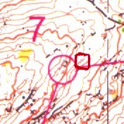
The 7th control on the second day was not in the right place. The scanned map is quite hard to read, but I drew a red circle around the place the control sat. The control was about 70 meters from the circle. It sat three lines below the circle. I spent a good 7-8 minutes looking for the control. I came right to the center of the circle and saw no flag. I then went to a big boulder due north of the control and attacked again. I came out at the same spot. I went back along the hillside, matched up some features and came back to the same spot. Then I just wandered around a bit, going down hill a bit and found the control. It might have gone quicker if it hadn't been foggy, since the fog cut how far you could see. After I ran, I went back out to the area with the two course setters. We confirmed the control wasn't in the right place and confirmed where it was. We also found the correct location. The place where the control should have been wasn't a good location. The mapped features were a bit vague. They really shouldn't have used it as a control location (though you could navigate to it). I don't know what they did. Did they throw out the results? Did they throw out the leg? Later, I was chatting with Nadim, Peggy and Eddie and mentioned that control 7 was misplaced. A guy I'll call "Peter Anderson" overheard us and came up and proclaimed that control 7 wasn't misplaced. "It was in the right spot." Well, Peter was wrong and I explained that I'd gone out there with the course setters and confirmed it was wrong and figured out where the control sat. I thought Peter's comment was odd. I could understand saying something like "it seemed ok to me." Or "I didn't lose any time." Or maybe "I'm not sure, I came right to it." Dinner is ready..time to stop writing. posted by Michael | 7:08 PM
Comments:
Post a Comment
|
|
||||
|
|
|||||