Occassional thoughts about orienteering
| okansas.blogspot.com Occassional thoughts about orienteering |
|
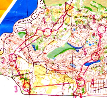
Thursday, March 20, 2003 Almost 20 years ago...I was looking at some old maps today. This is part of the M21 course from the 1984 Intercollegiate Champs (and Student WOC selection race). The Southern Michigan O' Club was the organizer.
I used to write about all my races. I wrote a sentence -- and usually more -- about each leg. I figured that writing about each leg would force me to think carefully about what I'd done on each leg. Hopefully, writing would help me learn. I also wrote a few notes about the area. If I ever went back to the map, or similar terrain, I'd take a look at the notes to remind myself about what to expect. Here is a bit of what I wrote back in 1984: Prospect Hill -- very nice map. The rockpiles are small, maybe 1-1.5 meters across and less than 0.5 meters high. In general, the woods were pretty good. Some trails were small, you had to be looking for them. Because of the recent rain the marshes were all distinct. Slow run areas are often juniper. Some of the juniper (e.g. between 9 and 10) was fast, but as it grows it becomes quite slow. I would stay out of any fight. 1->2 Better route may have been south to the trail (the other route has 3 contours less climb and the climb is spread out). 2->3 Thorn in my shoe -- stopped, untied shoe, checked for thorn, re-tied, ran about 50 meters and realized there was still something in it....same thing all over. Lost perhaps 2 minutes. Tried to just cruise into the marker, but I was too high. Didn't really look at the map. 3->4 No question - take the road. 4->5 The depression north of 4 surprised me. I expected a hill. posted by Michael | 8:15 PM
Comments:
Hi:
Post a Comment
I am going to make a link to you from my blog http://rockpiles.blogspot.com. If you feel inclined to stop by and leave a comment with more details about this location, maybe somebody could head out there and take some pictures of the piles. |
|
||||
|
|
|||||