Occassional thoughts about orienteering
| okansas.blogspot.com Occassional thoughts about orienteering |
|
Monday, February 24, 2003 Sonoran O'At our weekend training camp, Mook and I ran two O' sessions at a place called Maternity Well. My expectations were low, but the area turned out to be quite good for orienteering.The advice I'd been giving about running in Sonoran terrain was simple -- if it is vegetation, don't touch it. But, Maternity Well was covered in sparse grass, with widely scattered trees and only an occasional cactus. Mook took a snapshot of me running in the terrain. 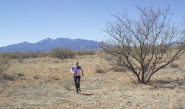
The photo might not make it look like an interesting area, but the terrain has a lot of spur/reentrant contour detail. You can get a good idea of the detail by looking at an aerial photo of the area. The shading in the area north of the road indicates the relief. Although the area is fairly flat with a lot of relatively fine contour detail, the O' map uses a 40 foot (12 meter) contour interval. The mapper handled the contour detail in an interesting way. Instead of adding contours (or even form lines), the mapper just drew the bottom of the reentrants as line features. The dotted black lines on the map below are the bottom of reentrants. 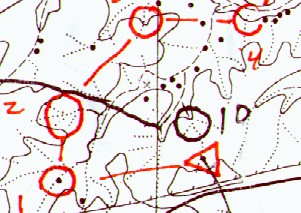
You can compare the map to the aerial photo. The road running across the aerial photo is the road a bit south of the start triangle on the O' map. The black dots on the O' map are the trees that show up on the west side of the aerial photo. I thought it was an interesting approach to mapping the contour detail. It isn't ideal, but it worked pretty well once you had a few kilometers of experience. It wouldn't be difficult to take the current O' map and improve it by adding contours (or form lines) using the dotted lines as a guide. Orienteering at Maternity Wells was fun. There is enough relief that you need to pay attention. There is enough detail that you could make a parallel error. The black dots are distinct oak trees. They are easy to see and cam make the navigation pretty easy at times. We ran with a black and white map. I'm not sure if there is a color map, but the black and white version was fine. If you'd like to see more of the map (and a bit of the control picking course Mook and I ran), you can see a larger section of the map. posted by Michael | 8:11 PM
Comments:
Post a Comment
|
|
||||
|
|
|||||
