Occassional thoughts about orienteering
| okansas.blogspot.com Occassional thoughts about orienteering |
|
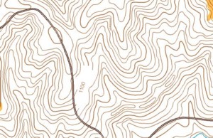
Monday, February 10, 2003 Field report from Indian CaveIndian Cave is the best O' area within two hours of Kansas City.Mary and I explored Indian Cave State Park (Nebraska) a couple of weekends ago. Possum Trot O' Club has a basemap -- really just a copy of the USGS map in OCAD. We took the map with us and spent about two hours running around the park. 
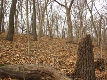
As you can tell from the map, the area is hilly (3 meter contours). For the most part, the contours are rounded. The USGS map does a decent job of showing the major features. There are also some interesting contour features that aren't captured in the USGS map. In places there are some erosion features and in places there are steep earth banks along the streams. There are also remains of some old farm roads and an area that must have been an old gravel/dirt pit (check out the row of elongated knolls running in a northeast direction on the lower part of the map shown above). The hills are long and steep. But not so long and steep that the area wouldn't make for good orienteering. The terrain is remarkably open. This photo shows a typical section of woods. 
Of course, some areas are a bit thicker. There are a few overgrown fields. The map we used didn't have trails on it. But, the park has a decent trail network. If I remember correctly, there are 30+ miles of hiking and horseback trails in the park. The biggest problem with the park is that it is the middle of nowhere. It is an hour or so south of Omaha (where there are a few orienteers but no club). It is 45 minutes or so east of Lincoln (where there is a big university, but no orienteers that I've heard of). It is an hour or so north of St Joseph (where there might be an orienteer, but there isn't a club). It is 2 hours north of downtown Kansas City. Two hours is a long way to drive for a mapper or for a club that is organizing an event. It makes for a good training day, though. You can drive up there, run in the forest for a few hours, then drive home. You can also make a weekend of it by overnight at the Lied Lodge. The lodge is a conference center in, of all places, Nebraska City, Nebraska. It is a nice place to stay and has decent restaurant (quite unexpected in a little place like Nebraska City). Maybe a rogaine? I'm hoping that PTOC will add the trails to the map, make a few changes to the vegetation boundaries using the USGS orthophotos, and host a 6-hour rogaine at Indian Cave. posted by Michael | 8:05 PM
Comments:
Post a Comment
|
|
||||
|
|
|||||